If one finds an exceptional arch and wishes to pursue a possible official naming of the arch and placement on a Topo Map contact,
U.S. Board on Geographic Names
U.S. Geological Survey
523 National Center
Reston, VA 20192-0523
(703) 648-4552
Found an arch?
If you are interested in contributing to the arch data base after locating an arch please note:
1) Make sure that your gps device is set to NAD 27 CONUS, settings need to be in DEGREES, MINUTES, SECONDS. Record the data.
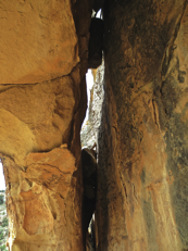
2) Take four photos, if possible, from different angles to show the arch. Show the crack between the wall and arch, from the bottom, side or top of arch.
3) Record as accurately as possible the width and height, with the width first. Minimum 3’0 opening. PLEASE NOTE, we are only recording arches that are at least six (6) square feet. Any arch under six square feet will not be included in the arch list.
4) Take a compass bearing from which the arch opening is seen to best advantage.
5) Upon returning from your trip, check the arch data base to verify and confirm your find.
6) Assign a name to your new discovery. Submit your information to cliffdwellinghomes@gmail.com to have the arch posted to the Arch Data Base.
This Website is following the system found in the book "Arches
of the Escalante Canyons and Kaiparowits Plateau" for arch determination and measurement. By doing this it allows for a uniform application of the same rules to all Arches in the GSENM.
This is a very brief and abbreviated overview on what constitutes an arch.
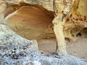
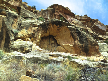
“An arch is simply a natural rock opening lighted from both sides with a secondary light opening at least three feet (3’0) in at least one dimension. No part of an arch has moved relative to any other part. An arch is not a cave, which has an area of total darkness, nor is it a hole through a boulder pile, where the opening is bridged by rocks that have moved.”
“Opinions differ on how to measure arches. the dimensions used at this web site are the greatest width and height of the opening below or behind the span of rock.”
To see current arch Statistics and data please click here.
PHOTO AT RIGHT WITH UPWARD LOOKING VIEW SHOWING MINIMUM 3’0 OPENING DIMENSION FROM BEHIND THE ABOVE ARCH. WIDTH CAN BE ANY DIMENSION WITH LENGTH BEING 3'0+
HEIGHT MEASUREMENT TAKEN FROM THE FRONT OF THE FACE BOTTOM SIDE TO WHERE THE VERTICAL LINE INTERSECTS THE FIRST HORIZONTAL PLANE
H
W

H
H
W

W
H